
116 3rd St SE
Cedar Rapids, Iowa 52401
USGS will fly ‘low-level’ planes over Eastern Iowa to look for critical minerals
The federal agency says the minerals can boost the economy and will bolster national security

Nov. 21, 2025 4:55 pm
The Gazette offers audio versions of articles using Instaread. Some words may be mispronounced.
The U.S. Geological Survey will be flying airplanes over parts of Eastern Iowa starting this month to help make new maps for the research group.
The mapping project, which will last about a year, will work to map out where critical mineral resources are within Iowa, Wisconsin, Illinois and Missouri, to help “modernize” the mapping of geology across the country.
The project will be in partnership with the four states’ geological surveys.
USGS’ push to make new maps is part of the agency’s Earth Mapping Resources Initiative, or “Earth MRI,” which is currently working to improve the “understanding of domestic mineral resources essential for energy, defense and economic growth.” The USGS is housed within the U.S. Department of the Interior.
Ryan Clark, associate state geologist with the Iowa Geological Survey at the University of Iowa, said the Earth MRI project has been “vital” to Iowa Geological Survey’s efforts to better understand critical minerals in Iowa and surrounding areas.
“The planned survey along the Upper Mississippi Valley will provide key information that will support ongoing research in the region focused on buried bedrock formations that are prospective for critical minerals such as rare earth elements,” Clark said in a USGS press release published this week.
Jamey Jones, science coordinator for USGS’ Earth MRI project, said not only will the initiative map out where critical minerals are located to help boost the U.S. economy, but it also will “bolster national security.”
“Partnering with the state geological surveys of Illinois, Iowa, Missouri and Wisconsin helps with the work of the nation,” Jones said. It “adds to state knowledge crucial to the resource economy, as well as water resources and natural hazards.”
What minerals are the researchers looking for?
According to the announcement from USGS, the minerals the agency is looking for include barite, cobalt, gallium, germanium, indium, zinc and what they called “rare earth elements.”
All of the elements are on the agency’s list of critical minerals that are essential to the country’s economy and national security.
For example, gallium, germanium and the “rare earth elements” are used in advanced technology and defense. China has restricted exporting those elements to the U.S.
The survey will take images of mineral resource potential within the Upper Mississippi Valley Mineral District, which is located in southwestern Wisconsin, northwestern Illinois and a strip of Eastern Iowa, along the Mississippi River.
Where the planes will be flying
The U.S. Geological Survey will be flying planes across four states to take images of the region's geology using "airborne geophysical technology." The planes will fly across Eastern Iowa, as well as Missouri, Illinois and Wisconsin.
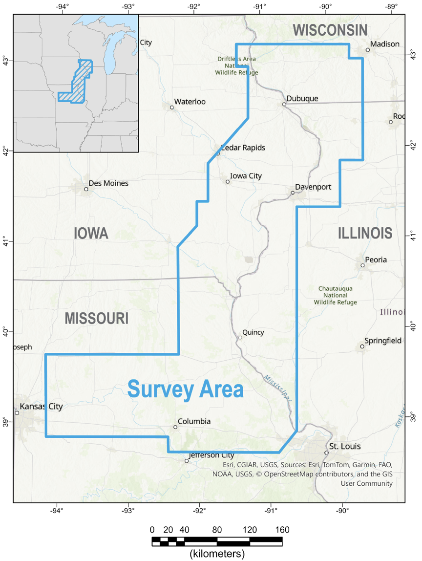
Source: U.S. Geological Survey
To assist with the project, USGS has contracted with Fugro, a geo-data solutions company and Xcalibur Smart Mapping, an airborne survey company to help collect the data from the airplanes.
The planes will be equipped with a “stinger” that holds sensors to collect the data.
USGS said the instruments used for the research won’t produce any emissions that would pose a risk to humans, animals or plants. The agency will not be collecting photography or videos from the planes and the flights will be conducted only during daylight hours.
“The aircraft will be flown by experienced pilots who are specially trained and approved for low-level flying,” the agency stated.
USGS said the pilots flying the planes will work with the Federal Aviation Administration to “ensure the flights are safe and in accordance with U.S. law.
Iowa counties involved in the mapping
The planes will flyover 22 Iowa counties, including: Allamakee, Cedar, Clayton, Clinton, Davis, Delaware, Des Moines, Dubuque, Henry, Jackson, Jefferson, Johnson, Jones, Keokuk, Lee, Linn, Louisa, Muscatine, Scott, Van Buren, Washington and Wapello.
Olivia Cohen covers energy and environment for The Gazette and is a corps member with Report for America, a national service program that places journalists in local newsrooms to report on under-covered issues. She is also a contributing writer for the Ag and Water Desk, an independent journalism collaborative focusing on the Mississippi River Basin.
Sign up for our curated, weekly environment & outdoors newsletter.
Comments: olivia.cohen@thegazette.com
 Daily Newsletters